I have decided to simply transfer my journal notes. A little more personal but really no different.
Thank you to John and Lyn Daly for their Take A Walk e-book.
The Werrikimbe Trail
Werrikimbe National Park
New England NSW
Notes from my journal.
Sunday, 21st December.
I am not sure if it is a matter of comfort in routine but my preference is for Thunderbolts Way to Walcha. The freeway, while quicker, is uninspiring.
Access was via the Oxley Highway heading west from Wauchope toward Walcha.
Take Kangaroo Flat Road and continue until you come to a fork in the road. Take Moorback Road on the right.
Continue along Morebahck Road until you enter Werrikimbie National Park and Cobcroft Road is on your immediate right.
Take Cobcroft Road. The Werrikimbe Trail is a locked gate about two kilometres from the intersection.
A further six kilometres from the trail head is Cobcroft Rest Area where we cook a quick lunch. I must admit to a great deal of anticipation at the start of this hike. Made all the more exciting to be sharing it with my beautiful wife.
A thunderstorm building in the Northwest produces some rather ominous sounds as we double check our packs at the trail head before we embark.
The storm clouds and its threatening thunder followed us the entire afternoon.

Trail head.


Good to go.
The Werrikimbe Trail winds East and our intended base camp was the Hastings River Crossing about eight kilometres from the trail head.
With only the occasional climb it is a relatively easy walk of only a few hours. The trail alternates from thick eucalypts to casuarina stands. Occasionally when the trail drops we encounter some rainforest habitat.


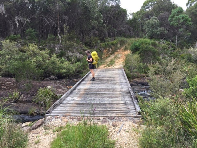
The trail to the Hastings River.

Fungi everywhere. If only I was confident identifying what is edible.
We arrive at the Hastings River mid afternoon. The timber bridge crosses a pretty, fast moving part of the river which is ideal for camping.


The Hastings River.
We decide to set up camp in a clearing to the right of the trail on the Eastern side of the bridge. Resisting the temptation to pitch the tent on the actual trail on the western side which is far more idyllic.

Camp site.
Shell pitches the tent while I begin filtering some drinking water and boiling water for the shower. While the temperature never broke 30C the inclines and the packs have us a both sweaty and a shower is a welcome luxury.
We eat dinner tonight on the bridge. Lamb and mushroom risotto and some dark chocolate.


An outstanding cook.
Sitting on the bridge at twilight with Shell, the water noisy over the rocks, I feel miles away from everything. People, houses, sounds, internet and that horrible artificial light that seems to permeate from everything. This is when I feel most content. Most in love with life. Sharing these moments with this amazing girl. This stunning country side.
It is dark when we settle into the tent. Dishes are cleaned and Shell has made a very reasonable effort to remove the terrible smell from my sweaty shirt. Night sounds. Water running in the river. Crickets and frogs. Just before we fall asleep fire flies put on a beautiful show for us. I am fascinated by these remarkable insects. A very pretty show as we fall asleep. A sleep which would have much more satisfying had I packed pillows.
Monday, 22nd December.
Dawn brings us an overcast sunrise that quickly burns off with the promise of fine but warm day.
Breakfast is on the bridge. Porridge with nuts and brown sugar. Over tea and coffee we decide to continue on the Werikimbe Trail rather than follow the Hastings South.
Travelling light with just the day pack we should cover plenty of distance.

Packed light.
From the Hastings River the track continues East and the further we travel the more likely it seems our destination is the Forbes River. An ideal spot for lunch.
The trail continues as it did the day before. Alternating between casuarina stands to thick eucalyptus.


Werrikimbe Trail East of the Hastings River.
As we pass through a casuarina stand we disturb a handful of Red Tailed Black Cockatoos. Impossibly black with remarkable crimson tails visible when in flight.

Red Tailed Black Cockatoos.
The trail is relatively easy with the occasional steep incline. As we approach a small clearing amongst ancient eucalypts we startle a Swamp Harrier. Over half a meter high it is an impressive predator. I can't help admiring this bird and feel it has risen above its rather underwhelming name.
According to the map we are within two kilometres of the Forbes River when the trail suddenly swings North and then North West.

What appears to be a nest with some small soft shell eggs.
The trail starts up a steep incline and we enter a cooling temperate rain forest. Enormous trees with fern in the understory.


A change in fauna.
We come across a locked gate at the top of the hill as the landscape opens into sparse scrub. The temperature has risen markedly in this terrain. As the trail continues to head away from the Forbes River and the surroundings remain the same we decide to head back to camp.
As we walk the trail the discussion turns to gaiters. We have both been irritated by grass seeds that defy all sense of physics. Shaped like a sperm they attach to your wooden socks then cunningly burrow their way to your skin. Although inanimate they seem determined to germinate in your ankles.

Possibly a grave in a clearing near camp.
We have returned to the campsite and had a late lunch. Shell is asleep on the picnic blanket while I do the dishes and filter some water. At some point she crossed the bridge and is on the Western side. I find comfort in watching her sleep. The sun is hot and burning my back. I don't mind. I feel totally relaxed and at ease.

Filtering water is my specialty.
After a swim we decide to shift the tent. Having slept in the shade of the eucalypts on the Western side of the river Shell is confident the track is seldom used and we pitch the tent on the track itself. We will risk a chance encounter with fellow hikers or the Rangers 4WD.

The new campsite from the bridge.
Having pitched the tent and cooled from the swim we lay about for the rest of the afternoon. With dapple shade and dinner a few hours away the temptation for sleep is almost irresistible. We hiked over sixteen kilometres today. While I am not tired the solitude of this place brings an overwhelming sense of relaxation. As my beautiful wife sleeps next to me and I write these words I am drowsy with happiness.

The tent pitched on the Werrikimbie Trail.

Dinner. Beef ragu.
Dinner is now done as are the dishes. Our last night before we hike back tomorrow. We decide on an early night and early start in the morning. Shell is always impatient. She does not bush walk. She marches from one pace to the next like she is preparing for battle. If an early start can be had, we will certainly have it!
As we lie in the tent now on the Western side of the river the fire flies return for a more spectacular show than the previous evening. I fall asleep before the performance is concluded.


The setting sun before the fire fly show.
Tuesday, 23rd December.
We are up at 4.30am. Shells eagerness to strike camp and set out is contagious.
Breakfast is the same as the previous morning. Pleasantly it is not a rushed affair and we take our time cooking and eating.
We break camp and double check both campsites and the bridge to make sure there is no trace of our stay. Thow on our packs and leave.
Rain threatens.
On the hike back we explore a side trail on the right. It leads North for a few kilometres before crossing a stream and opening into a clearing. If the trail continues past the clearing I cannot find it. I can't help but wonder where it leads. The bridge over the creek is certainly man made which indicates the trail has some purpose.
Soon after we start back on the Werrikimbe Trail Shell comes to a sudden halt. Her next step would have landed on a rather large tiger snake. Having just had breakfast it was unable to retreat off the trail. Instead it preferred to stay right where it was and make threatening gestures at out presence. Fortunately the same digesting animal that prevented it from departing also made it difficult to cause us any real concern and simply walked around it. Again the subject of gaiters is raised. Time to invest in some I think.

Tiger snake.
In a nearby stand of casuarinas we startle some Yellow Tailed Black Cockatoos. They don't excite me like their red cousins but are beautiful just the same.
Our last stop is an abandoned mine shaft. Approximately two kilometres from the trail head on your left hand side. Obscured by a fallen tree a few hundred meters will have you at the shaft. Certainly worth the detour.

Mine shaft trail entrance (looking East).


Abandoned mine shaft. The pictures do not do it justice.
With the trail head now in sight I will be relived to unload my pack but I am certainly not looking forward to seeing other people. Just as we approach the locked gate the rain begins to fall.

Back at the trail head as rain begins to fall.
We exit via Cobcroft Road. Which becomes Fenwicks Road as you enter Cottan-Bimbang National Park.

A pretty creek crossing in Cottan Bimbang National Park.
Finally Fenwicks Road becomes Seaview Road and arrives at the Oxley Highway after a scenic thirty kilometre drive.

At the Oxley Highway.
Home via Thunderbolts Way. First there will be lunch at a cafe in Walcha. I have ordered three main meals and feel reluctant to share. I am famished. It is raining outside and I feel claustrophobic with all the strangers chattering around me. I miss the bridge at the Hastings River already.
I am thinking 'where to next'? I look at Shell, I am positive she is thinking the same.
Good Read....went thru that area a few years back on the bikes. Stayed at the old school house near the Carria Plateau turn off. Magic area. Good read btw.
ReplyDelete